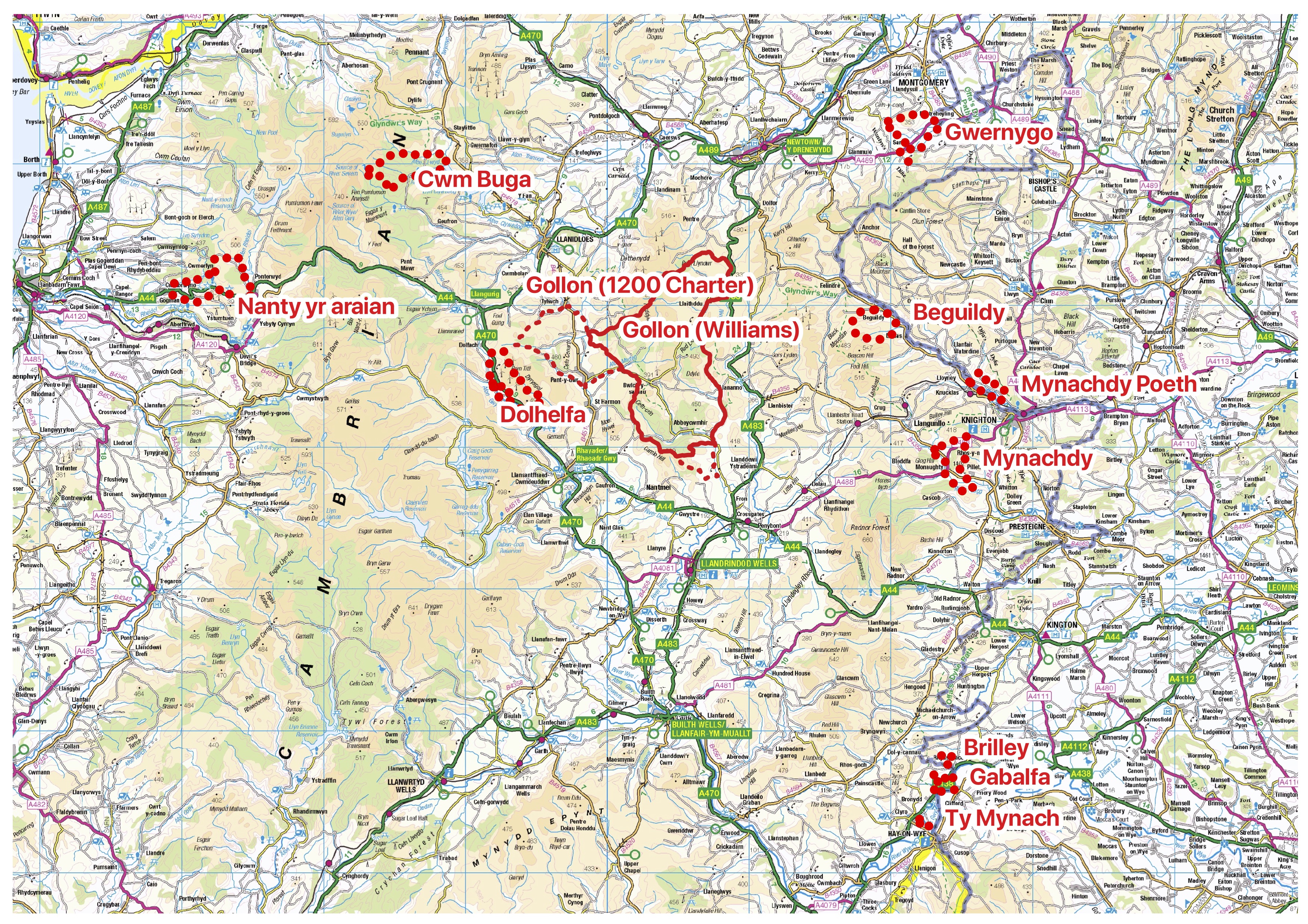
Where were the granges that belonged to Cwmhir Abbey?
People who have been on our Expert Led training events will know that we are interested to receive feedback on ‘humps and bumps’ that might tell us something about heritage in the landscape across all the Cwmhir Abbey granges. It is therefore incumbent upon us to try and define where these areas are……
However, this is easier said than done, as we depend upon interpretation of medieval charters, 19th century maps of properties and sheepwalks, estate records and on the ground walking to identify boundary banks, to interpret where these areas were. To complicate matters, the land owned by the abbey changed with time.
David H Williams prepared an Atlas of Cistercian Lands in Wales in 1990 and this forms the starting point for our further interpretation of these areas, however, Dr Jemma Bezant, Julian Lovell and Julian Ravest and others in our team are currently working to define these areas more closely. So in the meantime, we have included some maps here that are very much work-in-progress. Please expect them to change – but hopefully they give an early indication of the areas where we would love your feedback through this discussion area, or by email, of any heritage features that might be of interest to us. In addition, if you would like to help us define the boundaries of any of these granges then we would be super delighted to hear from you and we would discuss with you the types of research that you might like to do.
As our research team’s work is progressing we are holding discussions which have been recorded. Links to these discussions are provided here:
On 3rd December 2021 we held a research workshop where Julian Lovell explained how to access on-line information to help understand the boundaries of the granges. You can listen to the recording of his talk here.
On the same day Julian Ravest explained how the GIS system QGIS can be used to sort and interpret historical information. You can listen to a recording of his talk here.
From January 2022 we are holding monthly research discussion groups, so that we can share the progress we are making on researching the abbey granges. These discussions are being recorded and shared here.
January 2022 discussion – on the use of estate records to redefine the boundaries of Gollon, initial research on Cwm Biga grange, and the locations of mines and mills. Recording here.
February 2022 discussion – on the preparation of census information, tithe maps and other information into a coherent dataset. Recording here.
March 2022 discussion – on the findings of our Desk to Field weekend at Castle Bank near Red Lion, a possible medieval deer park at Abbey Cwmhir and investigating drainage at Gwernygo. Recording here.
April 2022 discussion – we discussed some of the granges, in particular Nant y Arian, Brilley and Gwernygo. Recording here.
June 2022 discussion – we discussed Gwernygo grange, Cwm Biga grange and drone photography of Moel Dod near Castle Bank. Recording here.
July 2022 discussion – we discussed Land tenure at Gwernygo etc, Update on Cwmffwrn excavations, abbey lands at Cwmbachllechryn and Defining the deer park. Recording here.
October 2022 discussion – we discussed Geophysics at Gwernygo; Post dissolution estates; Update on Cwmffwrn excavations; Painscastle. Recording here.
September 2022 discussion – we discussed: Update on Cwmffwrn excavations; Update on Gwernygo; Survey of Home Farm; Tithe maps of Llanidloes; Hay Local History Group; 3D image of Abbey. Recording here.
October 2022 discussion – we covered the results of the geophysics at Gwernygo; post dissolution estates; update on Cwmffwrn excavations; Painscastle. The recording is here.
January 2023 discussion – we covered Cwm Biga and New Well. The recording is here.
March 2023 discussion – we covered Mapping new abbey holdings, population studies at Abbeycwmhir and plan for excavations at Cwmffwrn. The recording is here.
April 2023 discussion – we covered Cistercian granges and farms, Charter by Madoc ap Maelgwn, Visualisation of the abbey, old routeways. The recording is here.
May 2023 discussion – we covered Bettws Chapel, Nant yr Arian estate map, National Library mapping conference, Townships, old routeways. The recording is here.
July 2023 discussion – we covered Nant yr Arian mining, Strata Florida excavations, Abbey holdings around Nantu, Medieval markets and fairs. The recording is here.
November 2023 discussion – we covered Placenames, Cwm Biga boundaries, Upland pastures. The recording is here.
January 2024 discussion – we covered Use of Radnorshire Society Transactions, Visit to Tintern Abbey, Dolhelfa, Cwm Biga, Gwernygo, St Harmon census, Brilly, Upland Pasture and Bridge building. The recording is here.
December 2023 discussion – we covered Upland pastures, Medieval and ecclesiastical land rights, Mortimer charter and ancient farms, Routes, Mills. The recording is here.
February 2024 discussion – we covered Cabalva grange; manors after dissolution; Townships, Manor of Gollon; Abbey build – stone and timing. The recording is here.
April 2024 discussion – we covered Deer Park; New HER records at Cwmffwrn; Chapter House at Abbey; Agriculture reference. The recording is here.
Julian Lovell’s reply:
Further to the discussion on boundaries to the southeast, I would suggest the following were also part of the Gollon Grange. This is based on my regressive studies of the sales of the Fowler estate c.1763 and a recitation (for legal purposes) of properties bought by William Fowler in 1565. So far, this method has proved to be 100% reliable. eg. Cenarth township
Purchased by Charles Gore:
Llwyn Noyadd, Scroll Ness, Cwybyr, Glen Shaffre, Borth Llwydd, Blaen Cwm Hebog
Avon Ucha, Bed Ugre Canol, Bed Ugre Usaf, Croft y Perthy, Lanerk Oley, Cwm Clyd, Hen Vryn, Pandy, Hae Ballok, Pen y Banc
Purchased by Jonathan Field:
Eskairwy aka Eskair Gollon, Kerrig Bach, Forky Tail (Bryn Camlo), Cwm Castle Pren
The last named is interesting, demonstrating a distant possession away from the grange. It is very close to the Mortimer Marlienydd castle of Cwmaron. It appears in Paul Refrey’s list of grange properties but he offered no explanation. The 1841 Census enumerator was also having trouble with some of these and had to alter the record. He included them in Gollon but by 1851 they were part of Llanddewi, initially included in a very small township named Church but quickly amalgamated with the township Maestirrhoslowry. We can unpack this as Maes-tir-rhos-clawdd-du – the bank of the field of rough pasture (a rough translation!). Clawdd (boundary bank) appears frequently in place names. Today the farm it was named after still exists at SO1007267471.
Aggie and Ed’s observations are shown here
Ed and I have noticed some interesting field patterns close to our home, possibly connected to the Abbey as they lie close to where we believe there was an original track to Abbeycwmhir. Julian Lovell has been in touch with us via email and has suggested they may form part of the Gollon Grange and we have sent him some further details marked on an ordnance survey map.
Found tonight’s (11 November) Update Zoom discussion fascinating and certainly gave me a greater insight into the various types of research that has been undertaken into the Granges. Particularly interested to see the images from the photogrammetry which showed so much detail. Many thanks to all the contributors.
Why haven’t you included the Granges in Nantmel, namely: Nantymynach (SO 014662) and Rhymney (SO 049680). There are 17 Granges listed in David Williams Monograph not 10 – where are they?
David William in ‘Atlas of Cistercian Lands in Wales’ lists 11 granges, which we show on this map. Williams lists Nantmel and Rhymney, with others, some of which are unknown, as ‘detached lands within Golon Manor’. They are not listed as separate granges. We are investigating these areas of interest, eg by doing drone surveys. We are currently working on defining these areas of these detached lands using tithe maps etc.